Gaviota Hot Springs Near Santa Barbara
Imagine you’re visiting the urban sprawl of Los Angeles on a foggy spring morning, and you decide to go for a day trip to the coastal mountains where you’ll hike for a couple of hours and soak in a natural hot spring pool. This day trip is possible at Gaviota Hot Springs, located in Gaviota State Park on California’s Central Coast. The two hot springs pools are easy to access via a well-cared-for trail.
Las Cruces Hot Springs
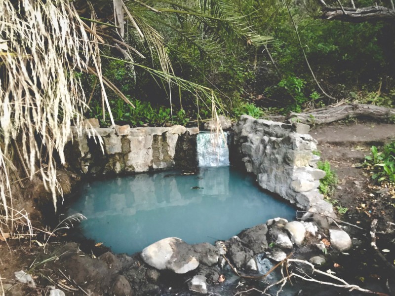
Gaviota Hot Springs is also known as “Las Cruces Hot Springs” because of its proximity to the unincorporated community of Las Cruces. If you drive 130 miles west of Los Angeles or 30 miles west of Santa Barbara on the 101 North highway, you’ll arrive at Gaviota State Park, where you’ll hike on a gradual, occasionally steep, 3-mile path. Hiking to the hot springs takes a couple of hours before reaching two rock-walled hot springs pools averaging 95°F to 100°F.
Weather and Best Times to Visit Gaviota Hot Springs
The Central Coast of California is often cool and foggy, with mild temperatures. During the spring months of February through April, evening and early morning temperatures may drop to freezing. However, daytime hiking almost every month will be pleasant. Avoid the late summer months of August through mid-October with uncomfortable daytime temperatures reaching or surpassing 100° degrees Fahrenheit. Check the daily weather forecast before hiking to the hot springs. In the summer, walk as early in the day as possible.
The ideal time to hike to Gaviota Hot Springs is in the late spring when you’ll see wildflowers between March and May. If you are only available to hike in the summer, avoid walking during the hottest hours of the day and avoid the longer park trails.
Camping in Gaviota State Park
Camping at or near the hot springs is not allowed. Camping is popular in Gaviota State Park due to its picturesque beachfront location, geological layers of rock, and classic railroad. Note that sites book up months in advance, so you may wish to book months ahead or on a weeknight. There are only 40 campsites that cost $45 per night, bookable on ReserveCalifornia.com.
If Gaviota State Park is fully booked, you may find a campsite at Refugio State Beach or El Capitán State Beach, 10 and 13 miles away, respectively. Refugio has 66 sites and El Capitán has 119 sites. Both beach campgrounds are just as popular as Gaviota, and both can also be reserved on ReserveCalifornia.com. All state beach campsites cost $45 (more for group sites).
Finally, if you can’t find a campground near Gaviota Beach, you may find a free overnight parking spot at the Arroyo Honda Vista Point, where you can stay for one, eight-hour time period. This spot offers no amenities like bathrooms and is best for self-sufficient RV or van-lifer travelers.
Driving Directions to Gaviota Hot Springs
The best way to get to Gaviota Hot Springs is from Santa Barbara, California, from where you’ll drive west for 30 minutes. Alternatively, you can drive west for two hours from Los Angeles. Going from Northern California will involve a five-hour drive south.
From Los Angeles, you’ll drive 130 miles west to the Gaviota Hot Springs trailhead, which is also the trailhead for Gaviota Peak. Go on the 101 North freeway from LA and pass the town of Gaviota Beach. Then take exit 132 for Highway 1 North towards Ojai but take an immediate right on the unmarked Gaviota Park Boundary Road, which is parallel to the 101 highway. Take this street until you arrive at the end of the road at a dirt parking lot. For directions from San Francisco, click on the map hyperlinked below.
Google Maps Directions
- From Los Angeles (about two hours and 130 miles)
- From San Francisco (approximately five hours and 300 miles)
Hiking Directions to Gaviota Hot Springs
The trail to Gaviota Hot Springs is straightforward, following the well-trodden path and fire road created by California State Parks. Here are two options for a day hike, one easy and one challenging trail:
- Hot Springs: Hike to Gaviota Hot Springs and back. Take a short yet steep trail up 400 feet to the hot springs. Altogether, the trek is less than 2 miles out and back on the fire road. Google Maps walking directions
- Gaviota Peak Loop: Hike to Gaviota Hot Springs and take the scenic route via the Trespass Trail. On this path, you’ll hike up 2,200 feet for approximately 3 miles to Gaviota Peak. In total, the loop will be just under 7 miles long. Read more about this trail on SantaBarbaraHikes.com.
Nudity and Hot Springs
Although nudity is not permitted at Gaviota Hot Springs, it is culturally typical for people to be naked at hot springs, and there have been reports of nudity at Gaviota.
Map
View map of all hot springs in California
Gaviota Hot Springs Soak Stats:
Season: All
Type: Hike
GPS (Trailhead): 34.504806816950115, -120.22572626054837
Map Quad: Solvang
Elevation: n/a
Land: Gaviota State Park
Parking Fees: Yes
Restrictions: State Park campground closed Jan 1 – Feb 28
Usage: Moderate
Visibility: Low
Temp: Between 95°F (35°C) to 100°F (38°C)
Water Clarity: Low/cloudy
Odor: Sulfur
pH: n/a
Area Features: Gaviota Falls, Gaviota Peak, Gaviota Beach, Gaviota Wind Caves, Nojoqui Falls Park
Nearby Hot Springs: Sespe, Ecotopia Hot Springs, Montecito, Sycamore, Avila, Willett
Closest Food/Gas: Buellton, CA (10 miles)
Trash: Moderate
Bugs: Moderate
Wildlife: Moderate
Camping: No camping at/near hot springs, see above for nearby camping options
Dogs: Yes (leash only)
Clothing-Optional: No
Pit Toilet: No
Goleta
California
93117
United States
Share this on:
- Click to share on Bluesky (Opens in new window) Bluesky
- Click to email a link to a friend (Opens in new window) Email
- Click to share on Facebook (Opens in new window) Facebook
- Click to share on Pinterest (Opens in new window) Pinterest
- Click to share on Reddit (Opens in new window) Reddit
- Click to share on Threads (Opens in new window) Threads



2 Reviews on “Gaviota Hot Springs”
Gaviota is a very relaxing hot spring, gets kind of busy on the weekends. It’s a mild hike up a steep road and then a trail to the side, waters not hot but very very warm
Just came from there. Hike in is easy. Water was warm (maybe about 80). Nice little adventure. Got very busy Saturday around 10.